
Active monsoon conditions will continue over central parts of the country during the next four to five days, according to the IMD
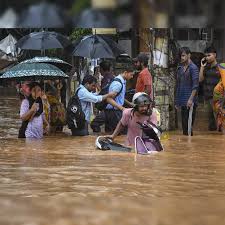
Heavy to very heavy rainfall with isolated extremely heavy rainfall (≥21 cm) has already been recorded over East Madhya Pradesh, Vidarbha and Tripura.
Heavy to very heavy rainfall (7-20 cm) has also been recorded at isolated places over West Bengal, West Madhya Pradesh, Chhattisgarh, Odisha, East Uttar Pradesh, Haryana; Heavy rainfall (7-11 cm) at isolated places over Jharkhand, Himachal Pradesh, Uttarakhand, West Rajasthan, West Uttar Pradesh, Coastal Karnataka, Mizoram and Meghalaya.
So far as the Delhi-NCR is concerned, the IMD says rains are expected to continue over Thursday and Friday.
Offering relief from the heat but also leading to heavy waterlogging in many parts of the national capital, rains continued through the night with minimum temperatures ranging between 25–27°C.
However, the weather affected flight operations at Delhi’s Indira Gandhi International Airport with some flights being diverted to Jaipur and Lucknow and causing delays due to the bad weather
The weather office has predicted a generally cloudy sky with moderate to light rain, accompanied by thunderstorms and lightning, in Delhi until July 15.
Northwest India
According to the IMD, light to moderate rain, along with thunderstorms and lightning, is likely at most or many locations across the Western Himalayan Region and multiple places in plains over the next few days.
Isolated heavy rainfall is expected over east Rajasthan and Uttarakhand between July 10 and 15, Jammu and Kashmir, Punjab, Haryana, and Chandigarh on July 10, Himachal Pradesh on July 10 and again during July 13 to 15, west Uttar Pradesh from July 10 to 13, east Uttar Pradesh from July 10 to 11, and west Rajasthan from July 12 to 15.
Very heavy rainfall is also expected over Uttarakhand, Uttar Pradesh, Punjab, and Haryana on July 10, and in East Rajasthan between July 11 and 13.
Multiple systems at play
There are multiple systems at play in the country, currently
The western end of the Monsoon trough runs north of its normal position and its eastern end runs near its normal position at mean sea level.
A Low-Pressure area over Gangetic West Bengal & neighbourhood lies over Gangetic West Bengal adjoining Jharkhand. The associated cyclonic circulation extended upto middle tropospheric level. It is likely to move slowly west-northwestwards across Jharkhand and north Chhattisgarh.
An upper air cyclonic circulation over north Haryana and another over northwest Uttar Pradesh & neighbourhood in lower tropospheric levels.
A trough runs from northeast Arabian Sea to the cyclonic circulation associated with Low-Pressure area over Gangetic West Bengal & neighbourhood across south Gujarat Region, north Madhya Maharashtra, Vidarbha, south Chhattisgarh, Odisha in middle tropospheric levels.
A trough runs from west Assam to Telangana in lower tropospheric levels.


